
SeaMarks For Your Computer
Waypoint/Data Management Program

$290.00
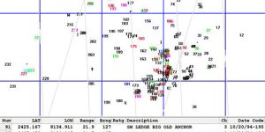
“Seamarks” is software for your computer designed to run on Windows based operating platforms. Seamarks contains the entire Maps Unique databases updated to 2025 by providing a northern or southern geographic coverage to choose. There are 4,000+ unique waypoints extending from Oregon Inlet, NC to St. Simon’s Island, GA.
All coordinates include, place names, bottom structure type/description, and water depth. Sites shown on chart plotter include all natural bottoms, all artificial reef structures, wreck locations and place names. Maps Unique data uses a special icon for distinguishing your own numbers from my data.
“Seamarks” has routines for organizing, displaying, printing, plotting, and planning that will provide coordination and clarity for all your waypoints. Yes— you can manually add or import your own waypoints to SeaMarks in either GPS or Loran. And yes, you can upload massaged data to a SD card and format it for import and export to your GPS model. You can also create your own custom colored maps along with custom log books of all your data and save and update these as needed. Seamark accepts GPS data, Loran data, or both. The program will automatically converts Loran coordinates to ASF corrected GPS coordinates.
1) North Includes Cape Hatteras, Cape Lookout, and Cape Fear
2) South Includes Murrells Inlet, Charleston, Beaufort SC and Savannah
“Nav-Unique” SD Cards
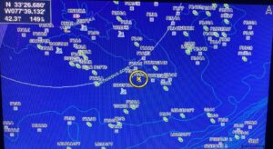
Maps Unique Waypoints/Data for your GPS

$259.99
The “Nav-Unique” product is provided on a Mini SD card, which comes with a standard SD card adapter included. This setup allows you to use the Mini SD card with devices that require either a Mini or standard SD card format.
Our Nav-Unique SD cards feature six expansive regions (listed below) with overlapping areas for comprehensive coverage to choose from. Each SD card pairs perfectly with our Maps Unique hardcopy map series for the Southeast, ensuring you have detailed, corresponding navigation both digitally and on paper. Each region contains over 1,000 unique waypoints, making manual imports a thing of the past!
Your selected SD card is loaded with detailed information for two large geographic areas, exactly matching the areas covered by our hardcopy printed maps. The data on each card includes all natural bottom sites, individual artificial reef structures, and wreck locations. Additionally, every waypoint is accompanied by a description that includes the place name, type of structure, and water depth. Chart plotters not only display these waypoints but also feature special Maps Unique icons that correspond to the hardcopy map sites, along with many place names.
Using the Nav-Unique SD card is straightforward. Just insert it into your GPS unit and select the function to upload the data. Our card is preformatted for compatibility with most GPS brands and models, including Garmin, Furuno, Simrad, Raymarine, Hummingbird, C-Map, and more, ensuring a seamless setup experience.
1) Hatteras/Cape Lookout 36°30 to 33°40 (Oregon Inlet, NC to Swansboro, NC)
2) Cape Lookout/Cape Fear 35°00 to 33°05 (Beaufort, NC to Carolina Beach, NC)
3) Cape Fear/Murrells Inlet 34°33 to 32°28 (New River Inlet, NC to Georgetown, SC)
4) Murrells Inlet/Charleston 34°00 to 31°43 (Southport, NC to Charleston, SC)
5) Charleston/Beaufort, SC 33°05 to 31°43 (Charleston, SC to Edisto River, SC)
6) Savannah GA/Beaufort SC 32°41 to 30°58 (Beaufort, SC to St. Simon, GA)