
SeaMarks For Your Computer
Waypoint/Data Management Program
$290.00
 “Seamarks” is software for your computer designed to run on Windows based operating platforms. Seamarks contains the entire Maps Unique databases updated to 2021 by providing a northern or southern geographic coverage to choose. There are 4,000+ unique waypoints extending from Oregon Inlet, NC to St. Simon’s Island, GA.
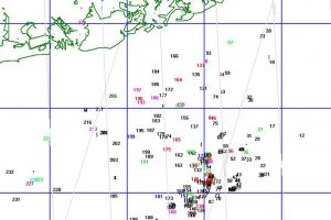
All coordinates include, place names, bottom structure type/description, and water depth. Sites shown on chart plotter include all natural bottoms, all artificial reef structures, wreck locations and place names. Maps Unique data uses a special icon for distinguishing your own numbers from my data.
“Seamarks” has routines for organizing, displaying, printing, plotting, and planning that will provide coordination and clarity for all your waypoints. Yes— you can manually add or import your own waypoints to SeaMarks in either GPS or Loran. And yes, you can upload massaged data to a SD card and format it for import and export to your GPS model. You can also create your own custom colored maps along with custom log books of all your data and save and update these as needed. Seamark accepts GPS data, Loran data, or both. The program will automatically converts Loran coordinates to ASF corrected GPS coordinates.
1) North Includes Cape Hatteras, Cape Lookout, and Cape Fear
2) South Includes Murrells Inlet, Charleston, Beaufort SC and Savannah